Time lapse imagery of the ice-off event at Lake Tarfala, Kebnekaise Mountains, northern Sweden, summer 2021
Nina Kirchner, Annika Granebeck, Daniella Lillieroth Charalambous
This dataset contains images of Lake Tarfala taken every 2 hours during the period from 1 June to 18 July 2021. During this period, the surface of Lake Tarfala transitions from being ice-covered to ice-free, an event referred to as "ice-off".
The dataset can be used to observe the ice-off event and to assign a date (or, rather, a time interval) to it. Knowledge of lake ice phenology, i.e. seasonal formation and loss of the lacustrine ice cover, is of importance since the timing of ice-off impacts lake processes such as stratification and vertical mixing.
The pictures were acquired using a camera positioned on the mountain flank along Lake Tarfala’s north-eastern shore, at 1220 m above sea level. In total, there are 432 images.
Download data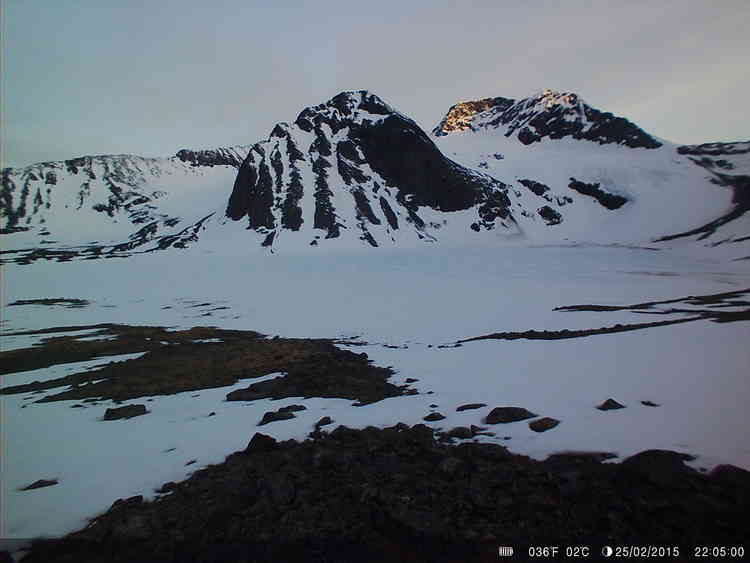
Scientific highlights
This dataset allows to assign a precise date to the ice-off event at Lake Tarfala in summer 2021. Defining ice-off as the first occasion after the ice-covered winter season on which the lake becomes completely ice-free and remains so for the rest of the summer, it was attained on 12 July 2021.Precise knowledge of the ice-off date can be used to:
- Assist in understanding lake mixing processes.
- Better constrain numerical models computing ice-off.
- Provide a complement to ice-off dates derived from satellite imagery, which is notoriously difficult in polar alpine environments due to persistent cloud cover and long polar nights.
- Lend support to alternative definitions of ice-off.
- Contribute to knowledge of lake ice phenology in high altitude Arctic environments under current climate change.
Some notable events in the time-lapse imagery of the diminishing lake ice cover include:
- 2 – 7 June: Retreat of ice cover along eastern lake shoreline (foreground of the picture, most visible 7 June at 23:05) in conjunction with onset of streamwater influx from stream system on the eastern lake bank (2 June from 01:05).
- 9 – 12 June: Increasing number of melt features on the central lake ice cover, mimicking surface meltwater ponds (most visible 9 June at 17:05 and 19:05).
- 21 – 23 June: Pronounced melting of ice cover in the north-western lake-corner where Kebnepakte Glacier drains into Lake Tarfala (right margin of picture, most visible 21 June at 19:05 and 23 June at 21:05).
- 6 – 9 July: Lakewide drift of ice floes, initially concentrated in the central, southern and eastern parts of the lake (6 July at 00:00 until 7 July at 8:00), subsequently concentrating in the northern lake-corner (7 July, from 12:00 until 14:00) and lastly, in the southern lake-corner where the lake outflow is located (8 July at 00:00 until 9 July at 22:00).
- 10 – 12 July: Final drift and disintegration of the season’s last ice floes.
- 17 July: Inflow of sediment-rich streamwater from stream network on the eastern lake bank (left margin of picture, at 04:00 until 12:00).
Map
Citation
Nina Kirchner, Annika Granebeck, Daniella Lillieroth Charalambous (2023) Time lapse imagery of the ice-off event at Lake Tarfala, Kebnekaise Mountains, northern Sweden, summer 2021. Dataset version 1. Bolin Centre Database. https://doi.org/10.17043/tarfala-kirchner-2023-ice-off-2021-1
Data description
The dataset consists of image files (JPG) of Lake Tarfala, with the date and time (Swedish daylight saving time, UTC+2) included in each photo. Due to complications with the date-and-time-stamp function of the camera during parts of the measurement series, incorrect dates and times are shown in the images taken between 1 and 23 June. Please refer to image file names for corrected dates and times, which follow the YYYYMMDD_HHMM format. Because of battery failure, no pictures were taken between 24 June and 5 July.
The pictures were acquired using a camera positioned on the mountain flank along Lake Tarfala’s north-eastern shore, at ~67.9° N, 18.6° E, at 1220 m above sea level.
The data were collected using a SiFar Willfine Trail Camera 4.0CG. The camera elevation is 1.8 m above ground. Each JPG file has a size of ~1 MB. The total size of the dataset is ~394 MB.
During a few short periods, fog, snow and/or rain obscures the view of the lake.
Comments
The support of our co-workers on the Arctic Avenue activity Lake thermal and mixing dynamics under changing climate (J. Weckström, K. Weckström, A. Korhola, and F. Schenk) is gratefully acknowledged.
Contact information
Email address
[javascript protected email address]Postal address
Nina Kirchner
Department of Physical Geography
Stockholm University
SE-106 91 Stockholm
Sweden
GCMD science keywords
Earth science > Cryosphere > Snow/ice > Lake ice
GCMD location
Continent > Europe > Northern Europe > Scandinavia > Sweden
Status
Completed
Dataset language
English
Project
The data were collected as part of a project within the Arctic Avenue Spearhead Research project between Stockholm University and the University of Helsinki, Finland, running between 2019 and 2022. It has contributed to this work through activity Lake thermal and mixing dynamics under changing climate.
Publisher
Bolin Centre Database
Begin date
2021-06-01
End date
2021-07-18
Dataset version
1
DOI
10.17043/tarfala-kirchner-2023-ice-off-2021-1
Published
2023-05-09 16:12:55